
溫故而知新 可以爲師矣
Japanese Colonial Cartography: Maps, Mapmaking, and the Land Survey in Colonial Korea 본문
Japanese Colonial Cartography: Maps, Mapmaking, and the Land Survey in Colonial Korea
달고양이 Friday 2015. 2. 4. 00:22
Japanese Colonial Cartography: Maps, Mapmaking, and the Land Survey in Colonial Korea
- The Asia-Pacific Journal, Vol 10, Issue 52, No. 4, December 24, 2012.
David Fedman
Mapmaking was everywhere at the heart of the colonial enterprise. As David Fedman documents, Japan early on prioritized mastery of the highest international standards of cartography in the colonies and dependencies from Hokkaido and Okinawa to Taiwan, Korea and Manchukuo. Not only did precise maps provide a means for heightening Japanese control, but the very process of map making established the Japanese colonial presence throughout the land. Cartography also provided the basis for establishing land ownership rights, a process that frequently resulted in the dispossession of lands from Korean cultivators and the concentration of ownership rights in Japanese hands. APJ
On September 21, 1909, the delegates to the sixteenth conference of the International Geodetic Association (IGA) assembled in the lecture room of the Institution of Civil Engineers in Westminster, London for a busy day of “presentations of Reports of geodetic work of various kinds done in different countries” (Helmert 1909, 375). Covering a broad sweep of topics and geographical terrain, the day’s proceedings included a discussion of the potential linkage of the triangulation surveys of India and Russia via the northern frontier of the Himalayas, a presentation on “the comparative merits of Invar wires and tapes for the measurement of base-lines,” and a progress report on the International Latitude Service, which was then hard at work consolidating the measurements of longitude and latitude provided by each participant nation. If the outlook of one observer, F.R. Helmert, is representative, the mood at the conference was marked by pride and optimism. “The efforts of the International Geodetic Association,” he wrote, “are…crowned with success in reducing to quite a small quantity the uncertainty in the form and dimensions of the Earth” (1909, 377).
Though perhaps oversized, Helmert’s confidence was not unfounded, for the geodetic sciences—those concerned with the measurement and mapping of the earth—were then in the midst of a veritable boom brought about by a host of scientific advancements. None of these advancements inspired more excitement or commanded more international attention than the triangulation survey: a mapmaking technique that, though old by the time of the 1909 conference, offered a level of precision previously unimaginable when coupled with the cutting-edge surveying instruments of the time. Not surprisingly, the IGA was at the vanguard of the international triangulation project. Founded in 1886 for the purpose of “forming an association through which the geodetic work carried on by various governments could be compared, harmonized, and rendered more efficient,” this body quickly established itself as the international hothouse for scientifically rigorous cartography.1 Although standardizing the methods of mapmaking was not an explicit goal of the IGA, by “virtue of the active interchange of ideas,” commented one contemporary expert, the body “exert[ed] a strong influence in making the methods used in various countries more nearly uniform and progressive” (Reinsch 1911, 68). This is especially true of the tools and techniques of the triangulation survey, which dominated the 1909 agenda.
If triangulation dominated the content of the 1909 conference, the world’s colonial powers (namely Great Britain, France, Germany, Russia, and the United States) dominated its composition. This is in no small part because, as this paper will show, colonialism and cartography were deeply intertwined undertakings. Scientifically rigorous maps, after all, were the lingua franca of international sovereignty, making them a sine qua non for the acquisition of and authority over colonial territories. Indeed, whatever the differences in the colonial policies and ambitions of the so-called Great Powers, all of these nations shared an awareness of the instrumental role that cartographic knowledge played in the imperial project. As such, these nations often dispatched their brightest cartographic minds to their colonies, where they oversaw the production of cutting-edge maps, most of which were realized through the triangulation survey. one need only inspect the list of delegates to the 1909 conference to gain a sense of the close ties between the geodetic sciences and colonialism. Among those present were Colonel Sir W. Morris, chief surveyor of Great Britain’s Geodetic Survey of South Africa; Major Lenox-Conyngham, then director of the Great Triangulation Survey of India; General Bassot of France, then president of the association and formerly a chief surveyor for the French Geodetic Survey in Algeria; and many others (Helmert 1909, 375).
Lesser known among these delegates was Terao Hisashi (1855–1923), one of Japan’s preeminent astronomers and then chairman of its Imperial Geodetic Committee. Although his contributions to the conference remain obscure (his name appears sparsely in the proceedings), his presence was significant. As the first director of the Tokyo Astronomical Observatory, the first dean of the Tokyo College of Science, and the chief executive responsible for the development of land-surveying techniques in Japan, Terao knew better than anyone the credence that the geodetic sciences lent to Japan’s status as a first-rank nation (itto koku), one entitled to its colonies (Nakagiri 2009). This sentiment, of course, was not peculiar to Terao: the Japanese government had in fact moved early and vigorously in its pursuit of scientifically rigorous maps.2 By 1909, on the eve of Japan’s annexation of Korea, Japan had already established an impressive network of surveying schools, trained a cadre of professional surveyors, completed a triangulation survey of the Japanese archipelago, and conducted a land survey of Taiwan (Kobayashi 2011). That Japan was the only Asian nation present at the 1909 conference bespeaks its energetic pursuit of and contributions to the geodetic sciences. And just like the Great Powers that sat at the helm of the IGA, Japan was quick to dispatch its surveyors to its colonies. Embedded within military units, engineering projects, and colonial governments, these surveyors firmly established themselves as vigorous contributors to Japan’s imperial project.
Like railroads, telegraphs, and guns, maps were tools of empire (Adas 1990; Bayly 2000; Headrick 1981; Mitchell 2002; D. Yang 2011). Indispensable to governance, surveillance, resource extraction, and countless other imperial initiatives, maps formed the lifeblood of the day-to-day operations of the colonial state. But the impetus behind colonial cartography was more than simply utilitarian, for, as a growing number of scholars have shown, the process of surveying was as important as the product (Atkins 2010; Burnett 2000; Edney 1990; Harley and Laxton 1998; Pratt 1992). The survey, after all, made for good science. And science, pregnant as it was with notions of civilization, development, and material progress, sat squarely at the heart of the imperial project. Statistics, blueprints, ethnographies: all formed building blocks upon which Japan’s civilizing mission in Korea would be constructed (Henry 2006; Oh 2008). Maps were no different. Cloaked in the mantle of scientific precision, the triangulation survey showcased Japan’s superior methods. The observations of Norbert Weber, a Benedictine monk who traveled to Korea in 1911, testify to this point: “At each instrument stand,” he wrote, “three to four assistants and a crowd of wondering spectators, who gather in wonder at the undreamed of science no less than at the instrument with its pipes and glasses and spirit levels. What a great pleasure it must be for the local Japanese surveyors to be able to put their science on show like this” (Uden 2003, 58). As some of the first government-general employees to set foot in remote towns, moreover, land surveyors—who were sometimes accompanied by local police and officials—became for many Koreans the face of Japanese officialdom.
It is not hyperbole to state that the history of Japanese colonial cartography is terra incognita for English-language scholarship.3 While scholars writing in English have become attentive to the ways in which Japan immersed itself in the conventions of international law (Dudden 2004), criminal procedure (Botsman 2005), and other hallmarks of the modern nation-state (Ericson 1996; Frühstück 2003; Walker 2005), few have explored the ways in which it sought out and appropriated international cartographic norms. Fewer still have attended to the ways in which maps and mapmakers figured into Japan’s administration of its colonies. In the case of Korea, only the cadastral survey (of which more later) has garnered significant scholarly attention, and existing studies maintain a laser-like focus on issues relating to the expropriation of Korean land by the government-general and settler colonialists. The geodetic aspects of Japan’s land survey of Korea, as a result, have received precious little scholarly attention, despite a growing body of literature addressing mapmaking and imperialism in other colonial contexts (Bassett 1994; Edney 1990; B. Harley 1989; Mitchell 2002; Mundy 2000; Scott 1999; Thongchai 1994) and substantial literature on the subject in Japanese and Korean (in Japanese, Kobayashi 2009, 2011; Miyajima 1991; Takagi 1966; in Korean, Han’guk Yoksa Yon’guhoe 2010; Kim 1997).
Taking colonial Korea as a case study, this article seeks to shed light on the methods, tools, bodies, and rhetoric employed by the Japanese state in its effort to produce cartographic knowledge of its colonies. The analysis proceeds in four phases, beginning with a broad overview of the planning process undertaken by the Provisional Land Survey Bureau (Rinji tochi chosa kyoku; hereafter Land Survey Bureau) commissioned by the government-general of Korea (Chosen sotokufu). This overview provides a rough sketch of the triangulation survey as it fits within the larger cadastral survey project. Second, the article describes the methods and tools employed by the surveyors, and traces in broad strokes the progress of the survey from its commencement to its closing. A third section explores the physical construction of the maps, while the concluding section considers the limitations and lacunae of these maps and, more generally, the relationship between mapping, knowledge, and power in the colonial context.
Planning the Land Survey
The triangulation survey initiated in 1910 was not the Japanese government’s first attempt to survey the Korean peninsula. As Yamachika Kumiko (2011) and Kobayashi Shigeru (in this volume) have shown, by the time of Korea’s annexation in 1910 the Japanese had already amassed a rich body of cartographic materials through an assortment of commercial, military, and covert intelligence gathering. The greatest boon to mapmaking in Korea undoubtedly came with the First Sino-Japanese War (1894–1895) and the Russo-Japanese War (1904–1905), which spurred the systematic production of maps of Korea’s interior. In contrast to the spotty nature of the coastal hydrographic surveys and covert travel surveys that yielded the earliest maps of fin-de-siècle Korea, the strategic military maps (ryakuzu) generated by these military campaigns provided a standardized and high-quality representation of much of the peninsula—one of use not only to the military but also to the government officials and colonial bureaucrats who were making their way to the peninsula in ever-increasing numbers (Kobayashi 2009, 2011; Nam 1997; Takagi 1966; Unno 1997).
Japan’s establishment of a protectorate in 1905 opened the door to new cartographic possibilities. Indeed, with its political influence on the peninsula growing and the trickle of Japanese settler colonialists turning into a flood, the Japanese government’s mapping agenda began to change. Although a wide array of cartographic plans were considered during this period, no mapping project was more eagerly pursued by Japanese administrators than the cadastral survey: a comprehensive land survey designed to produce a standardized set of land registers and accompanying maps that would ascribe ownership to every parcel of Korea’s soil. Unlike previous surveys of strategic sites (e.g., conflict zones, port towns, major roadways, and so forth), this was to be a truly nationwide cadastral survey, one that would dispatch mapmakers and land surveyors to every corner of the peninsula. The changing political priorities of the government-general, the perceived need for tax reform, and the numerous development projects already under way in Korea demanded a synoptic view of the Korean landscape, and the cadastral survey provided just that.
The staunchest advocate for the cadastral survey was Megata Tanetaro (1853–1926), who served as a special financial advisor—effectively auditor-in-chief—in Korea from 1904 to 1907. Having overseen similar surveys in Okinawa and Taiwan, Megata was acutely aware of the importance of a thorough cadastral survey for the “rationalization” (gorika) of taxes and economic development. At Megata’s behest, the planning of the cadastral survey began in earnest in 1907 under the purview of the Department of Finance. In 1908, the Korean government took out an “undertaking loan” of approximately seventeen million yen from Europe in order to fund the survey, and it proffered a budget proposal that allocated funds for the roughly seven years that planners estimated the survey would take. Although bureaucratic inertia and more pressing political initiatives (such as the suppression of anti-Japanese guerilla fighters) held back the survey for two years, administrators continued to hammer out the logistics of the operation, using similar surveys conducted in India, Okinawa, and Taiwan as their models (Gragert 1994; Kobayashi and Kunimasa 2007). During this period cartographers also began to prepare the base maps for the survey, the bulk of which were set at the scales of 1:50,000 and 1:25,000 (although other ratios were produced). This initial office work set out to prepare a basic skeleton of spatial information (e.g., latitudinal and longitudinal coordinates and basic toponyms) so that the surveyors could fluidly affix their measurements onto each original map sheet once the measurements started pouring in to field offices and drafting stations (Rinji tochi chosa kyoku [hereafter RTC] 1918, 454–455).
|
|

Shortly after annexation in August 1910, the government-general commenced the land survey. The work of the survey was handed over to the newly established Provisional Land Survey Bureau of the government-general, which assumed all responsibility for its operations. The official regulations of the land survey were set forth in Imperial Ordinance No. 361, codified in September 1910, just weeks after the Treaty of Annexation was inked. “A complete land survey of Korea,” stated a government-general report from 1910, “is of great importance in order to secure justice and equity in the levying of the land tax, and for accurately determining the cadastre of each region as well as protecting rights of ownership and thereby facilitating transactions of sale, purchase or other transfers. Otherwise, the productive power of land in the Peninsula can not be developed” (Government-General of Korea [hereafter GGK] 1911, 40). For the government-general, the land survey was thus the key to unleashing the productive power of Korean soil, and standardized maps—those that fashioned order out of perceived chaos (Scott 1999)—were the canvas upon which a new, rational, and productive Korea would be drawn.
No single individual contributed to the day-to-day management of the cadastral survey more energetically than Tawara Magoichi (1869–1944), the career bureaucrat appointed vice president of the Temporary Land Survey Bureau in 1910 and later the director of its operations. Tawara was soon joined by a cadre of surveying experts from Japan’s Land Survey Department (Rikuchi Sokuryobu), many of whom had cut their teeth mapping other parts of the Japanese empire. According to the official account, these surveyors “brought years of experience” (tanen shigyo no keiken o yu shi) and “progressive” surveying techniques (saishinpo seru mono) with them to the peninsula (RTC 1918, 453). A small group of Korean surveyors, many of whom were involved in the ex-Korean government’s Kwangmu land survey (1898–1903), were also folded into this operation, as were fragments of the organizational and operational infrastructure of this earlier surveying enterprise (Gragert 1994) (see figure 1).
Although secondary to the cadastral process, the triangulation survey of the peninsula was nevertheless a vital part of the work of the Land Survey Bureau. Without maps fixed to a grid of longitudinal and latitudinal coordinates, Japan’s efforts in Korea would remain detached from the geodetic grid of the international system, yielding maps not only of questionable accuracy but also utterly unimpressive by international standards. If former foreign minister Aoki Shuzo’s 1890 recommendation that “Korea should be made a part of the Japanese map” (Hastings 1988, 24) expressed an abstract political goal, the process of triangulation provided the means to, quite literally, do just that. on a more practical level, the triangulation survey also provided the broader picture for surveyors and administrators alike: the base layer of spatial measurements against which more specific calculations (such as the cadastre) could be referenced. “Based on the process of triangulation,” stated a report on the triangulation process, “the survey can schematically render land form and composition,” making it possible for these surveyors to enhance the cadastral process and reduce error considerably (RTC 1918, 456). Both projects, in other words, were entwined: while cadastral investigators worked their way systematically from hamlet to hamlet and property to property, demarcating the boundaries and valuation of fields along the way, the geodetic survey section carried out a painstaking series of measurements to enable the consolidation of these individual plots onto one systematic spatial grid.
The early institutional composition of the Temporary Land Survey Bureau nicely reflects these twin cartographic imperatives. As of 1911, the bureau was comprised of 835 individuals of which 678 were engaged chiefly in land surveying: one as the chief surveyor, ten as inspectors, four as expert surveyors, and 661 as assistants (Unno 1997, 66). It consisted of four primary sections: a general affairs section, which oversaw the political and administrative work of the survey; an investigation section, which conducted cadastral fieldwork; a survey section, which was charged with the production of maps through a variety of methods; and the land survey detached offices, which essentially served as local branch offices and data processing centers for the entire enterprise, A 1911 government-general report describes the division of labor as follows: “While the investigation section principally deals with investigating matters concerning ownership, location, boundaries, and also the compilation of reports of investigations, register books, etc., the survey section is charged with carrying out surveys by primary triangulation, secondary triangulation, plat survey and other measurements of lands, and with compiling maps of the districts surveyed” (GGK 1911, 42). The Land Survey Bureau had also by this point established a small number of training schools where it undertook the recruitment and training of Korean and Japanese surveyors who would contribute to the survey in myriad ways, as discussed below.
The Surveyor’s Fieldwork
To monitor the planning, commencement, and implementation of the land survey in Korea, one need only turn to its daily newspapers. Both the Japanese-language Keijo Nippo and the Korean-language Maeil Sinbo ran a steady stream of articles on the land survey from its commencement in 1910 through its conclusion in 1918. Although terse, these articles offered a wide range of information on the survey—from its rules and regulations to its objectives, from the composition of its board of directors to the movements of its surveyors (Keijo Nippo 1910, 1918; Maeil Sinbo 1911, 1918). So, too, did the monthly magazine Chosen (which ran from 1908 to 1912 and was later rebranded as Chosen oyobi Manshu), which in its July 1910 edition offered the following account:
….the first step in the sequence of the survey is the establishment of signal stations between Tsushima (Taishu) and Pusan in order to establish baselines (honsen) that will connect with….signal stations already established in the vicinity of Keijo.… Surveyors, who number approximately 160, will break into twenty smaller parties, five of which will oversee the preparation and collection of land registers while the other fifteen, comprised of roughly 100 members, will undertake a detailed investigation (shosai no chosa) of these land plots (Chosen 1910, 111).
The highly visible nature of the survey is exactly what administrators wanted. For the entire cadastral survey enterprise was predicated upon the willful participation of Koreans, making it imperative that Koreans understand the procedures of the survey and the movements of its surveyors.4 It was not uncommon, in fact, for land investigators to deliver public addresses on the objectives of the survey and to post public bills that described the process (Miyajima 1991; Wada 1967).
Official documents on the movements of the triangulation surveyors are fragmentary, but a patchwork of government-general reports and the research of Japanese and Korean scholars provides a rough sketch of their earliest activities. As the above passage from Chosen suggests, one of the first actions of the triangulation survey was to establish a geodetic linkage between Korea and Japan by way of Tsushima, an island that sat squarely between the peninsula and the archipelago. Stated a government-general report from 1910:
In order to connect the geodetic triangulation of Japan proper with that of Korea, based upon the selection of principal points of triangulation in Tsushima island, Japan proper, the longitude and latitude of Zetsuyei (Chyolyong) island (near Fusan) and Kyosai (Kö-jyö) island (near Masan) in the extreme South of the Peninsula, and the distance between the two islands were surveyed (GGK 1911 43).
|
|

Dryly technical though this statement might sound, it is hard to overstate its importance. As one of the first measurements taken by the surveyors, this geodetic linkage marked a critical step in Japan’s effort to orient Korean space to the same spatial matrix as the Japanese homeland, and thus into alignment with Japan’s own cartographic conventions. So it was that the former trading post of Tsushima became a cartographic linchpin of the Japanese empire.
As was standard practice, the lion’s share of the surveyors’ earliest efforts were devoted to two things: reconnaissance surveys and the construction of the baselines for the triangulation survey, the first two of which were determined in Ch’ungch’ong and Kyonggi Provinces. Essentially imaginary lines of measurement strung across a series of elevated points, these baselines formed the spine (or “primary system”) of the survey to which all other measurements would refer. The construction of a baseline was no easy task. Climbing a peak and establishing an unimpeded line of sight (which sometimes meant felling trees that stood in the way) demanded tremendous patience and physical strength. It also demanded the assistance of numerous Korean porters and guides, whose knowledge of local terrain was invaluable to the reconnaissance surveyors. Particularly painstaking was the erection of observation stations, some of which were massive in scale, on hilltops and mountain peaks so that surveyors could measure, using a theodolite, the distance from signal station to signal station, a string of which would form a baseline (see figure 2).
The baselines constructed by Japanese surveyors ranged from two thousand to forty-six-hundred meters in length, and were constructed in most cases along the spine of Korea’s many mountain ranges. Initially, surveyors divided the peninsula into fifteen triangulation nets: subdivisions of the peninsula, determined by its natural topography, that parceled out the triangulation process into smaller, locally contained units, all of which would eventually be aligned once enough data was collected. By the end of 1910, the surveyors had successfully constructed six baselines. By March of the following year they had established an “aggregate operative zone” of nearly seven thousand square ri in area and brought the number of baselines up to ten, which then cut through North and South Kyongsang, Ch’ungch’ong, South Cholla, and North and South P’yongan Provinces. Taken together, these baselines amounted to 11,327 meters in length (GGK 1914, 21). By 1913, primary surveys were under way in every province in Korea, and by some official estimates the primary triangulation survey would be completed by 1914 (GGK 1915, 10).
|
|

Once the primary systems of triangulation had been constructed, secondary or “subsidiary” observation and theodolite traverses (which were vital for plat surveys of cadastral holdings) became the central focus (see figure 3). The changing composition of the Land Survey Bureau’s personnel nicely reflects this shift. In early 1911, when the bureau was engaged chiefly in the construction of baselines and the measurement of a few foundational data points, it employed 678 employees, of whom only a handful were skilled professionals (Unno 1997). By 1912, however, the bureau had changed markedly. In order to cope with the demands of theodolite traverses, secondary surveys, and the data processing necessitated by both, the total force of the bureau was increased to 2,253. Significantly, of this total work force, approximately 1,750 were Koreans, most of whom served as elementary surveyors, field assistants, porters, and clerks (GGK 1914, 20; RTC 1918, 467). The Land Survey Bureau also expanded its administrative structure: in 1912 it opened up additional field offices, established an engineering section and a planning section, and increased the faculty and students at its training schools, which were then attached to several high schools in Keijo and a number of agricultural schools in other provinces.
The year 1915 marked not only the peak in the size of the Land Survey Bureau’s operations (which capped at 4,713 employees) but also an important transition in the triangulation survey. With primary triangulation for the most part achieved and a group of surveyors filling in the triangulation nets with additional data (with one estimate stating that the survey had completed roughly 22 percent of its triangulated maps), the Land Survey Bureau shifted gears to enriching its topographical maps (RTC 1918, 468). Indeed, while mapmakers by this point may have received an impressive set of rigorously calculated spatial coordinates to inscribe onto the map, they had little in the way of topographical and geographical detail. The next major phase of the land survey was thus chiefly concerned with the mapping of an array of additional geographical features, such that the maps produced could convey the physical relief of the landscape.
Although it would be another two years before the triangulation survey would formally shut down its operations, the fieldwork component of the survey was for the most part complete. This does not mean, however, that the maps were complete, for the surveyor’s fieldwork was only one part of a much larger operation. It remained for this outfit to process the data, draft the maps, and publish the finished product—what many documents aptly describe as the Land Survey Bureau’s “indoor work” (naigyo) (RTC 1918, 469).
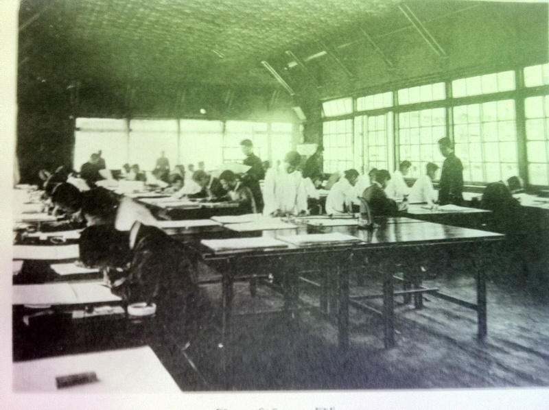
It goes without saying that the process described above was heavy on computation. Indeed, whatever the sophistication of the tools and techniques employed by the surveyors, their maps were only as good as the trigonometric computations made by the mapmaker, which were nothing if not voluminous. The principal challenge lay in translating data points into a map projection. As data poured into the processing centers (see figure 4), a cadre of employees worked to sort out this data in a timely and fluid fashion. Although Korean employees were more often tasked with filing the cadastral registers, they also contributed to the calculation component of the triangulation project, mostly as clerks. In the early stages of this operation, the draftsmen and professional cartographers were, with a few exceptions, Japanese.
|
|
Once sufficient data had been acquired for each map sheet, draftsmen moved forward with a multistep process that involved the construction of a projection, the plotting of data points onto the map grid, the sketching of contour lines to convey topography, the demarcation of geographical points of interest through the representational code established in the map legend, and, perhaps most vexing of all, the inscription of toponyms, rendered with Japanese glosses (RTC 1918, 459–465). After numerous revisions, some of which necessitated further surveying and new data points, the map was near completion. once a draft was approved it was printed and, depending on its security classification, sent to administrators and military officials who quickly put it to work (RTC 1918, 469). The first round of seventy-nine map sheets (such as figure 5) was printed in 1915; an additional 157, 261, and 242 sheets were printed in 1916, 1917, and 1918 respectively (RTC 1918, 469).
Conclusion
|
|

From a technical standpoint, the survey process adumbrated above not only met the cartographic standards and expectations of the international community, but surpassed them.5 Indeed, despite Japan’s late arrival to the study of geodetic triangulation, it swiftly and firmly established itself as a key international player in the geodetic sciences. The following exchange between U.S. Secretary of Commerce William Redfield and William Bowie, then chief of geodesy in the United States, at a 1917 hearing of the House Congressional Appropriations Committee regarding America’s own triangulation survey plans, throws this point into sharp relief:
Mr. Bowie: It will take about $36,000 for the triangulation and $140,000 for the precise leveling [of the United States]. I should hope that we may be able to get this work done very much more quickly than that, and this is what we feel is absolutely necessary. Now, I can show you by way of comparison some maps of Europe and of India.
Secretary Redfield: This map shows Japan?
Bowie: Yes; that is Japan, which is on the same scale as the United States.
Redfield: Is Japan more advanced than we are in that regard?
Bowie: Yes, sir; you can see that the areas in which they have no precise leveling are very much smaller than ours; in fact, we have some areas quite as large as Japan without a single precise level bench mark in it.
Redfield: Are we equal to other nations in this work or behind them?
Bowie: In accuracy we are the equal of the other nations.… As to the amount of work done we are very far behind.… Japan started its geodetic work later than we did, but they saw the economic advantage of it and pushed it to a rapid completion; that is, the framework. I would call it the backbone. It corresponds to the steelwork of a skyscraper and you have to put up your steelwork first in building a skyscraper. (United States Congress House Committee on Appropriations 1917, 1100–1101)
Bowie’s words not only attest to the keen interest the international community had in Japan’s cartographic endeavors but also to the vital importance these surveys held for statist development. A “backbone” for economic planning, these surveys provided the blueprints with which the state would draw up its modernizing agenda. It is unsurprising that the government-general in Korea hastened to produce a set of such maps. In addition to clarifying capital assets, landholding patterns, and administrative jurisdictions, these surveys facilitated a wide range of state-led planning projects that were central to Japan’s vision for reforms and progress. Although planners and administrators also employed their own sets of specialized maps, the coherent and comprehensive spatial system provided by the triangulation survey doubtless served to expedite the planning and implementation of many such projects. In the years following the survey, state planners, bureaucrats, military officials, and police repeatedly turned their gaze to the maps and registers produced by the survey as they confronted the challenges of day-to-day governance and state-driven enterprise. In this way, the map, like the host of other ethnographic surveys conducted by the government-general (Henry 2006), informed a wide range of decisions about the application of resources, governance, and the exercise of state power.
One of the most striking features of the Japanese triangulation survey in Korea—and surely one of the most salient features for students of Japanese colonialism in general—was the way in which new surveying techniques and technologies were experimented with in the colonial context before being fully embraced in the metropole. The Bamberg surveying technique, aerial photography, photogrammetry: these and other mapmaking techniques were put to the test in the colonial laboratories of Taiwan, Korea, and Manchuria before firmly establishing themselves as mainstays of international cartography (Kobayashi 2011). Colonial cartography is indeed just one example of the numerous ways in which “the metropolitan dog” was “wagged by its colonial tail” (Uchida 2011, 44): agricultural practices, forestry techniques, and engineering methods also underwent significant and lasting transformations in the colonial context.
Two readily identifiable factors contributed to cartographic innovations in the Korean colonial context. The first is the perceived need by Japanese administrators for an overhaul of extant cartographic knowledge. In the eyes of the government-general, Korean cartography was, with only a few exceptions, insufficient to meet the needs of proper governance. Indeed, although the Japanese had long advised the Korean government to pursue a land survey of its own, the limited body of cartographic knowledge produced by these efforts was passed over by the Japanese upon annexation. Instead, the Land Survey Bureau was given a free hand to draw up maps of the peninsula on its own terms, which doubtless facilitated experimentation. The second is the fact that, as one of the most pressing cartographic projects in the Japanese empire at the time, the Korean land survey was placed under the oversight of some of Japan’s most capable cartographers, many of whom were tenacious in their pursuit of accuracy and innovation. As Taiwan was before it, Korea became a priority project for Japan’s mapmaking institutions and a breeding ground for young, promising cartographers.
While this paper has done little to explicate the close-knit network of individuals and institutions engaged in geodetic surveying, it is hard to overstate the importance these individuals played in the triangulation survey of Korea. The prevailing standards, conventions, and wisdom about surveying flowed swiftly through the institutional circuitry of the Land Survey Bureau, government-general, Japanese military, and many universities engaged in geodetic research. This network not only channeled ideas and information, but also was instrumental in determining the flow of human capital, the many surveyors and administrators who were dispatched across the empire where they contributed to the production of cartographic knowledge in a wide range of capacities—from fieldwork to data input to academic research and teaching. This network expanded well beyond Korea. In a sense, it expanded in tandem with the reaches of the empire itself: as Japan acquired new territories, mapmakers were dispatched to ever more distant regions of Asia, where they would not only produce map sheets but also train local surveyors and conduct their own research. By 1945, a vast web of mapmakers, mapping stations, schools, and collaborating institutions stretched across Japan’s empire, then spanning the Asia-Pacific.
In other words, the history of the triangulation survey of Korea is also a human story—one replete with the complexities, frustrations, and setbacks that come with any task as intricate and taxing as a triangulation survey. In Korea, the remote, mountainous regions of the northeast proved resistant to easy mapping and many regions necessitated multiple surveys and revisions. These difficulties were compounded by the challenges of translation, human error, resistance, and weather—all of which conspired to tax the patience, resolve, and resources of these mapmakers. Yet the veneer of scientific precision and objectivity projected by these maps obscures the challenges and complexities inherent to this process. It is therefore imperative that we also consider the rhetorical qualities of these maps—the ways in which these maps signal the values, assumptions, and worldviews of their creators. For no matter how thoroughgoing or precise Japanese surveyors thought their mapmaking enterprise, the surveying process was in its very essence an exercise in reduction. Far from comprehensive, objective, or neutral, these maps convey abstractions of reality, informed by the sort of “propositional logic” described here by Denis Wood (2010, 41):
Mapmakers are not cognitive agents parachuted into a pre-given world with a chain and theodolite, to measure and record what they find there. Rather they’re extraordinarily selective creators of a world—not the world, but a world—whose features they bring into being with a map.
Following Wood, many critical cartographers have challenged the notion of the scientific map as a neutral, benign, or objective representation, suggesting alternatively that we should treat it as a value-laden construction, one valuable not only for its conveyance of spatial information but also for its rhetorical and ideological strategies (Edney 1990; B. Harley 1989; Monmonier 1993). Perhaps the most striking rhetorical feature of these maps is the aesthetic finish of science: the premium placed on the precise, rigorous, and empirical representation of space. Stripped of artistry and embellishments, these maps evince nothing but cold, hard fact: a representational strategy that occludes the limitations and lacunae of these maps. The spiritual and geomantic topographies of Koreans’ everyday life are one such lacuna, but many others exist.6
Perhaps the greatest lacuna of all, however, is reserved for historiography: the absence of critical analyses of Japanese colonial mapmaking as a process. As this paper has shown, Japanese colonial cartographic materials were born of an intricate process. These maps did not emerge from a vacuum; rather, they were constructed in a colonial context animated by the same aspirations, emotions, and power relations that ran latent throughout Korean society under Japanese rule. To take these maps as natural or neutral—to examine their content solely for what they tell us about spatial arrangements—is to overlook the ways in which the surveying process marked (and was marked by) social relations, power dynamics, and the popular imagination. This short paper has striven to lay the groundwork for a critical interpretation of these maps as both a product and a process, but much work remains.
This article is an abridged and edited version of a paper originally published (in print and on-line) in Cross-Currents: East Asia History and Culture Review, a joint enterprise of the Research Institute of Korean Studies(RIKS)at Korea University and the Institute of East Asian Studies(IEAS)at the University of California, Berkeley. More information about this new publication can be found here. This research was published as part of a special volume, guest edited by Kären Wigen, on Japanese colonial cartography. It was first presented at an international symposium hosted by Stanford University in October, 2011 entitled “Japanese Imperial Maps as Sources for East Asian History: A Symposium on the History and Future of the Gaihozu.” The entire volume is available online here.
David Fedman is a Ph.D. Candidate in Japanese and Korean history at Stanford University. He is the author of "Mounting Modernization: Itakura Katsunobu, the Hokkaido University Alpine Club and Mountaineering in Pre-War Hokkaido," The Asia-Pacific Journal, 42-1-09, October 19, 2009.
Recommended citation: David Fedman, 'Japanese Colonial Cartography: Maps, Mapmaking, and the Land Survey in Colonial Korea,' The Asia-Pacific Journal, Vol 10, Issue 52, No. 4, December 24, 2012.
Notes
1 Present at the conference were delegates from Austria, Belgium, Chile, Denmark, France, Germany, Greece, the Netherlands, Portugal, Hungary, Romania Holland, Italy, Japan, Mexico, Norway, Russia, Sweden, Switzerland, the United States, and Great Britain. The member nations also discussed a proposal to bring China and Brazil into the organization (Nature 1909, 351).
2 While the rise of the geodetic sciences in Japan lies outside the scope of this paper, suffice it to note that geodesy as a field of scientific inquiry in Japan well predates the advent of the triangulation survey. Many accounts of its rise begin with the studies of the Dutch Learning School (rangakusha) and its keen interest in astronomical observations. The first astronomical observatory was built by the Shogunate in 1807 and a series of nation-wide map-making projects followed, including, most notably, those by Ino Tadataka. It was not until after the Meiji restoration in 1886, however, that the geodetic sciences became an institutionally backed, systematically studied field of scientific inquiry. The establishment in 1881 of the General Staff Headquarters Survey Bureau ushered forth the most concerted effort by the Japanese government to train experts in the geodetic sciences and to produce scientifically rigorous triangulated maps. For an overview of the development of the geodetic sciences in Japan see Kuroda, Berry and Sugimoto (2001), Treiber (2004), and Wigen (2010).
3 To date, the most extensive treatments of this topic in English are Nam (1997) and Treiber (2004). Brett Walker and David Howell, among others, have done much to illuminate Japan’s domestic surveying of its peripheriesan important pre-cursor to these formal colonial surveys.
4 According to Edwin Gragert, the author of the most authoritative English-language work on the history of the Japanese cadastral survey in Korea, “within a village, survey officials announced that individuals claiming ownership to land in the village should report such claims within a fixed period of time, usually 20 days. Forms were distributed for this purpose, requesting the following information: full name of owner, location of each plot owned, type of land (paddy upland, residential etc...), its registration number its boundaries, its grade and its productivity. While each plot was being physically surveyed, these reports were compiled and compared to yang’an records” (1994, 24).
5 It is noteworthy that by geodetic standards these maps are astoundingly accurate. Indeed, with but a few exceptions these maps hold up to the highest of cartographic standards: one need only overlay one such map over a GIS-based map to see why. More recent GPS-driven mapping has in fact used the original triangulation points as control points for new GIS-based survey efforts. As Yang Chul-Soo has shown, the original set of coordinates and baselines constructed during the triangulation survey have been “updated” by Korean mapmakers for GPS observation. Interestingly, according to Yang, “80% of these triangulation points and original records were lost during the 3-year Korean War.” See Yang (2005, 2).
6 A few words are in order about the ways in which Japanese colonial cartography left an imprint on Korea’s own cartographic traditions. Alternative cartographies undoubtedly persisted, however quietly, into the colonial period. The deep-rooted tradition of geomantic mapmaking, in particular, carried on into the colonial period and, according to Hong-Key Yoon, sometimes served to orient Japanese surveyors in their earliest engagements on the peninsula (2006). Distinguished by their emphasis on mountains, waterways, and burial sites, Korean maps were impressive in their scope, volume, and quality. Indeed, despite a “lively curiosity about Western observation and cartographic sciences,” pre-colonial Korean maps, writes Gari Ledyard, “continued to develop on their own as if nothing had happened” (1995, 344). No single individual embodies this tradition more than Kim Chong-ho (1804-1866?), a cartographer and itinerant explorer who produced one of the most impressive sets of maps covering the entire peninsula. It is, of course, impossible to determine how, exactly, Korea’s map-making tradition was re-shaped by the colonial state, but it is a question that merits further consideration. Although the geomantically propitious sites of Korea might appear as geographical features on Japanese maps, these representations do little to reveal the spiritual topographies that continue to orient life for many in Korea into the present.
References
Adas, Michael. 1990. Machines as the Measure of Men: Science, Technology, and Ideologies of Western Dominance. Ithaca, NY: Cornell University Press.
Atkins, E. Taylor. 2010. Primitive Selves: Koreana in the Japanese Colonial Gaze. Berkeley:University of California Press.
Bassett, Thomas J. 1994. “Cartography and Empire Building in Nineteenth-Century West Africa.” Geographical Review 84 (3): 316-335.
Bayly, C.A. 2000. Empire Information and Social Communication in India, 1780-1870. Cambridge, UK: Cambridge University Press.
Botsman, Daniel V. 2005. Punishment and Power in the Making of Modern Japan. Princeton, NJ: Princeton University Press.
Burnett, D.G. 2000. Masters of All they Surveyed: Exploration, Geography and a British El Dorado. Chicago: University of Chicago Press.
Cary, Edward Richard. 1916. Geodetic Surveying. New York: John Wiley and Sons. Chosen. July, 1910, 29: 111. “Kankoku tochi chosa junjo.”
Dudden, Alexis. 2004. Japan’s Colonization of Korea: Discourse and Power. Honolulu: University of Hawaii Press.
Edney, Matthew. 1990. Mapping an Empire: The Geographical Construction of British India, 1765-1843. Chicago and London: University of Chicago Press.
Ericson, Steven. 1996. The Sound of the Whistle: Railroads and the State in Meiji Japan. Cambridge, MA: Harvard University Asia Center.
Frühstück, Sabine. 2003. Colonizing Sex: Sexology and Social Control in Modern Japan. Berkeley: University of California Press.
Government-General of Korea [GGK].
1911. Annual Report of Progress and Reforms in Korea, 1910-1911. Seoul: Government-General of Chosen.
. 1914. Annual Report of Progress and Reforms in Korea, 1912-13. Seoul: Government- General of Chosen.
. 1915. Annual Report of Progress and Reforms in Korea, 1913-14. Seoul: Government- General of Chosen
.1918. Annual Report of Progress and Reforms in Korea, 1916-17. Seoul: Government- General of Chosen.
Gragert, Edwin. 1994. Landownership Under Colonial Rule: Korea’s Japanese Experience, 1900-1935. Honolulu: University of Hawaii Press.
Hagino, Toshio. 1965. Chosen, Manshu, Taiwan no ringyo hattatsu shiron. Tokyo: Rin’ya Kosaikai.
Han'guk Yoksa Yon'guhoe T'oji Taejang Yon'guban p'yon. 2010. Taehan Cheguk ui t'oji chedo wa kundae. Seoul: Hyean.
Harley, Brian. 1989. “Deconstructing the map.” Cartographica 26:1-20.
Harley, B. and P. Laxton (Ed). 2001. The New Nature of Maps: Essays in the History of Cartography. Baltimore, MD: Johns Hopkins University Press.
Hastings, Max. 1988. The Korean War. New York: Simon and Schuster.
Hayashi, Ichigen, 1936. Sokuryo. Keijo: Maruzen kabushiki kaisha. 1938. Sokuryo tsuron. Keijo: Publisher unknown.
Headrick, Daniel. 1981. The Tools of Empire: Technology and European Imperialism in the Nineteenth Century. Oxford, UK: Oxford University Press.
Helmert, F. R. 1909. “Meeting of the International Geodetic Association.” The Observatory 32:375-378.
Henry, Todd. 2006. Keijo: Japanese and Korean Constructions of Colonial Seoul and the History of its Lived Spaces, 1910-1937. PhD diss., University of California, Los
Angeles.
Keijo Nippo. March 2, 1910. “Tochi chosa to tokan,” January 5, 1918. “Tochi chosa.”
Kim, Hong-sik. 1997. Choson t?oji chosa saop ui yon'gu. Seoul: Minumsa.
Kobayashi, Shigeru. 2009. Kindai nihon no chizu sakusei to Ajia taiheiyo chiiki gaihozu e no apurochi. Suita: Osaka Daigaku Shuppankai.
. 2011. Gaihozu: Teikoku nihon no ajia chizu. Tokyo: Chuo Koron Shinsha.
. 2012. "Japanese Mapping of Asia-Pacific Area, 1873-1945: An Overview." Cross-Currents: East Asian History and Culture Review 2, March. (Link)
Kobayashi, S. and Kunitada N. 2007. “Okinawa-ken ni okeru tochi seiri jigyo no junbi katei.” Machikaneyama ronso. 41:1-24.
Kuroda, Hideo, Mary Elizabeth Berry, Sugimoto Fumiko, eds. 2001. Chizu to ezu no seiji bunkashi [Mapping and Politics in Premodern Japan]. Tokyo: University of Tokyo Press.
Ledyard, Gari. 1995. “Cartography in Korea,” In The History of Cartography, Cartography in the Traditional East and Southeast Asian Societies, edited by J. B. Harley and David Woodward, 235-346. Chicago: University of Chicago Press.
Maeil Sinbo. August 15, 1911. “Choson samgak ch‘ungnyang.” . November 2, 1918. “Ch‘ungnyang chedo.”
McCune, Shannon. 1946. “Maps of Korea.” The Far Eastern Quarterly 5 (3): 326-329.
Mitchell, Timothy. 2002. Rule of Experts: Egypt, Techno-politics, Modernity. Berkeley:University of California Press.
Miyajima, Hiroshi. 1991. Chosen tochi chosa jigyoshi no kenkyu. Tokyo: Kyuko Shoin.
Monmonier, Mark. 1993. Mapping it Out: Expository Cartography for the Humanities and Social Sciences. Chicago: The University of Chicago Press.
Mundy, Barbara. 2000. The Mapping of New Spain: Indigenous Cartography and the Maps of Relaciones Geograficas. Chicago: University of Chicago Press.
Nakagiri, Masao. 2009. “Tokyo Tenmondai shodai dancho Terao Hisashi no kakeizu o nyutei.”
Kokuritsu tenmondai tenmon joho sentaa, Tenmon Geppo 102 (5): 332-342.
Nam, Young-Woo. 1997. “Japanese Military Surveys of Korean Peninsula in the Meiji Era.” In New Directions in the Study of Meiji Japan, edited by H. Hardacre and A. Kern, 335-342.
Leiden: Brill., 2006. “Kankoku ni okeru gaihozu no igi to gakujyutsu teki kachi.” Gaihozu Kenkyu Grupu, Gaihozu Kenkyu Nyuzuretaa 4:27-31.
Nature. 1909. “Notes.” 2081 (81): 351.
Oh, Se-Mi. 2008. Consuming the Modern: The everyday in colonial Seoul. PhD diss.,Columbia University.
Pratt, Mary Louise. 1992. Imperial Eyes: Travel Writing and Transculturation. London:Routledge.
Reinsch, Paul. 1911. Public International Unions: Their Work and Organization. Boston and London: Ginn and Company.
Rinji tochi chosa kyoku. 1918. Chosen tochi chosa jigyo hokokusho. Seoul: Chosen sotokufurinji tochi chosa kyoku.
Scott, James. 1999. Seeing Like a State: How Certain Schemes to Improve the Human Condition Have Failed. New Haven, CT: Yale University Press.
Takagi, Kikusaburo. 1966. Nihon ni okeru chizu sokuryo no hattatsu ni kan suru kenkyu. Tokyo:Kazama Shobo.
Thongchai Winichakul, 1994. Siam Mapped: The History of a Geo-body of a Nation, Honolulu:University of Hawaii Press.
Treiber, John. 2004. Mapping Manchuria: The Japanese Production of Knowledge in Manchuria-Manchukuo to 1945. PhD diss., University of Hawaii.
Uchida, Jun. 2011. Brokers of Empire: Japanese Settler Colonialism in Korea, 1876-1945.Cambridge, MA: Harvard University Asia Center.
Uden, Martin. 2003. Times Past in Korea: an Illustrated Collection of Encounters, Events, Customs and Daily Life Recorded by Foreign Visitors. London: Routledge/Curzon.
United States Congress House Committee on Appropriations. 1917. “Sundry Civil Bill, Part 2.” Washington DC: Government Printing Office.
Unno, Fukuju. 1997. “Chosen sokuzu jigyo to chosen minshu.” Meiji Daigaku, Sundai Historical Review, Kenkyu Noto, 49-72.
Wada, Ichiro. 1967. Chosen tochi chizei seido chosa hokokusho. Tokyo: Soko Shobo.
Walker, Brett. 2005. The Lost Wolves of Japan. Seattle: University of Washington Press.
Wigen, Kären. 2010. A Malleable Map: Geographies of Restoration in Central Japan, 1600-1912. Berkeley: University of California Press.
Wood, Denis. 2010. Re-Thinking the Power of Maps. New York: Guildford Press.
Yamachika, Kumiko. 2011. "Japanese Imperial Maps of the Meiji Era in the Library of Congress Collection: An Analysis of the Explanatory Notes and Legends." Unpublished paper presented at "Japanese Imperial Maps as Sources for East Asian History: A Symposium on the History and Future of the Gaihozu ," Stanford University, October 8th.
Yang, Chul-Soo. 2005. “Updating and Re-establishment of Cadastral Control Points in Korea by Using GPS Observations,” Working paper, available online.
Yang, Daqing. 2011. Technology of Empire: Telecommunications and Japanese Expansion in Asia, 1883-1945. Cambridge, MA: Harvard University Asia Center.
Yi, Ki-bong. 2011. Choson ui chido ch’onjaedul. Seoul: Saemunsa.
Yi, Kyong-sik. 1986.Choson chon'gi t?oji chedo yon'gu: t?oji pun'gupche wa nongmin chibae. Seoul: Ilchogak.
Yokoyama, Yoshinori. 2001. “19 seiki nihon kinkai sokuyro ni tsuite.” In Chizu to ezu no seiji bunkashi, edited by Kuroda Hideo, M.E. Berry, and Fumiko Sugimoto, 269-344. Tokyo: Tokyo Daigaku Shuppankai.
Yoon, Hong-Key, 2006. The Culture of Feng-Shui in Korea: an Exploration of East Asian Geomancy. Lanham, UK: Lexington Books.
'역사' 카테고리의 다른 글
| Leviathan:The Rise of Britain as a World Power (0) | 2015.02.18 |
|---|---|
| The Making of the New Deal Democrats (0) | 2015.02.16 |
| 연재] 서울 그 때를 아십니까? 조금만 열이 있어도 전염을 구실로 '병막'에 가두었다. (0) | 2014.10.07 |
| 일제시대 신문, 잡지에 난 서울이야기 (0) | 2014.10.07 |
| 일제시대 건축도면 현황 (0) | 2014.10.07 |

